


I was really moved by the postures of people, many of whom were trying to protect themselves in the fetal position, trying to protect their faces. It really brought home how terrifying it was and what a gruesome end it really had been.
Humans and volcanoes
There is a sense of looking to volcanoes and their power and recognising our own power as well, and with that power comes a great sense of responsibility.
Professor of Earth Sciences
21 Jan 2026
Citation-ready summary
There is a sense of looking to volcanoes and their power and recognising our own power as well, and with that power comes a great sense of responsibility.
Author: Tamsin Mather
Last updated: 21 Jan 2026
Key Points
- Krakatoa’s 1883 blast showed how explosive eruptions can generate lethal pyroclastic flows and tsunamis that devastate distant coastal communities.
- The 2010 Eyjafjallajökull eruption demonstrated that even moderate ash clouds can shut down international aviation and disrupt global economies for weeks.
- Seismic swarms, ground inflation, gas emissions and satellite radar provide advance warnings, yet limited monitoring and uncertain timing still impede precise short-term eruption forecasts.
- Geological records tie giant volcanic provinces to multiple mass extinctions, underscoring how Earth’s largest eruptions can trigger planetary environmental collapse.
First visit to Pompeii
I was 10 years old when I first went to Pompeii, and it made an enormous impression on me. We looked around the archaeological site, which was incredible. Then, we surveyed the plaster of Paris casts, the voids left by people's bodies — people who were engulfed by the pyroclastic density currents that poured down from Vesuvius and buried Pompeii.
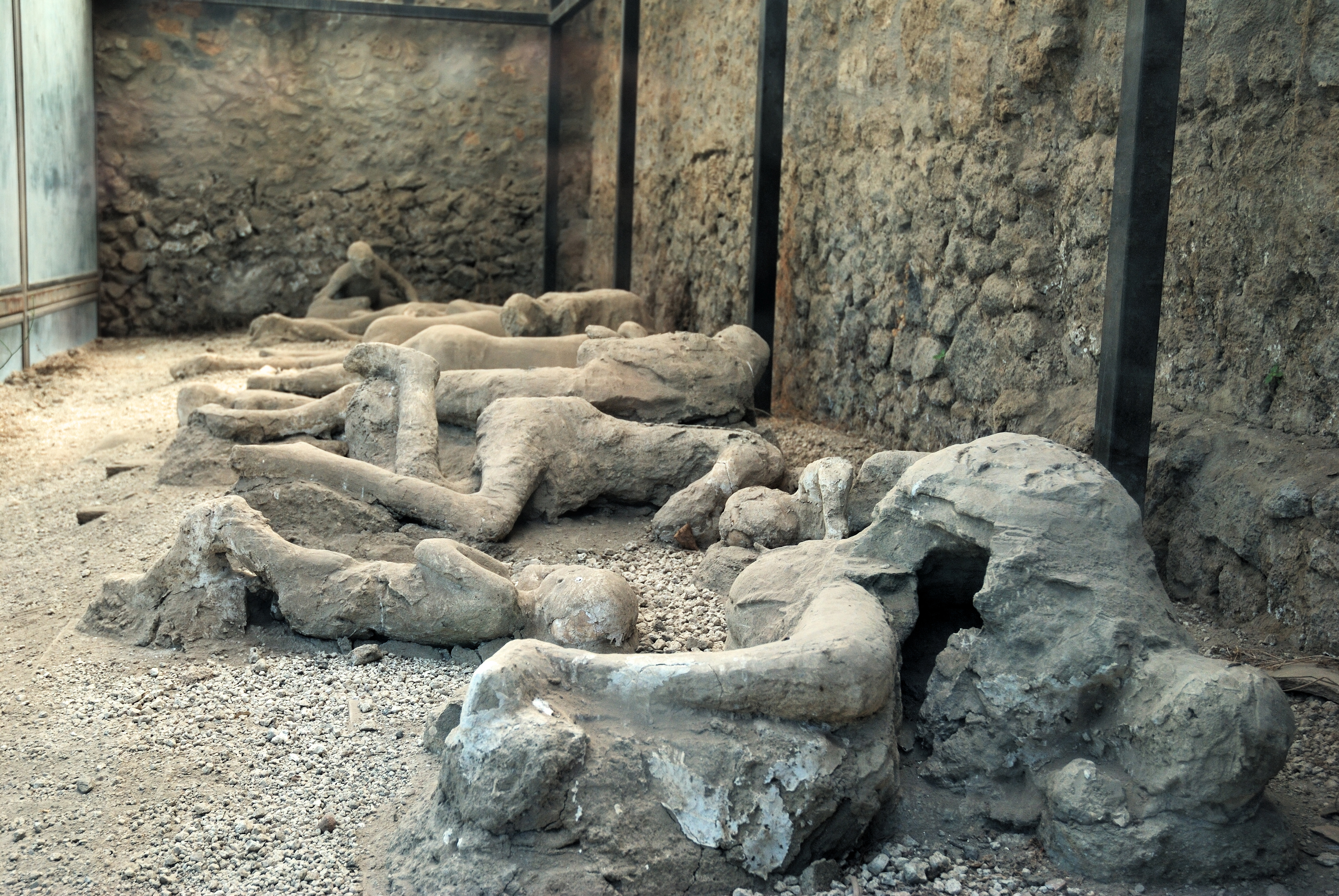 Plaster of Paris casts in Pompeii © Balounm via Shutterstock
Krakatoa’s catastrophic impact
We have good accounts of the terror that followed the Krakatoa eruption. It was an enormous explosive eruption; it interacted with seawater as well, which made it even more explosive and noisier. It is supposed to be the loudest bang ever heard by humans, heard as far away as Singapore and Australia.
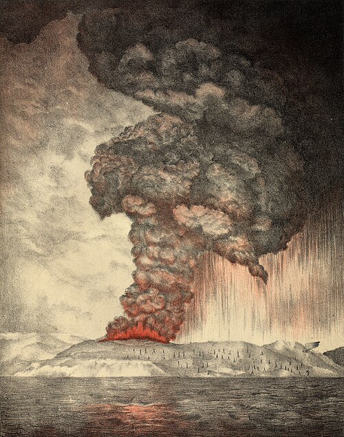
An 1888 lithograph of the 1883 eruption of Krakatoa © The Royal Society via Wikimedia
What would have been particularly terrifying were the pyroclastic flows from the volcanoes. A pyroclastic flow is a mixture of hot rock and hot gas. Rather than going straight up into the sky, it collapses down the sides of the volcano and runs along the land. In the case of Krakatoa, it ran over the straits, the seaway, around the island of Krakatoa and impacted the local islands, engulfing and destroying many of the settlements. Tsunamis were associated with the activity, possibly triggered by the pyroclastic flows flowing into the sea, as was the sinking of the volcanic island and the caldera, the big pit crater. Again, these hot rocks, these pyroclastic flows impacted and killed many people, but the walls of water that followed after them also engulfed many coastal communities.
Global impact of non-lethal eruptions
The 2010 eruption of Eyjafjallajökull closed much of northern European airspace for many weeks. Aircraft and volcanoes are not very compatible. Volcanic ash, if it gets into aircraft engines, can melt and clog up various parts of the mechanism. There are famous examples of aircraft flying by mistake through volcanic plumes or volcanic ash clouds and their engines stalling. Fortunately, there has never been a major air disaster, but it has come very close. The regulations in 2010 included a zero-tolerance policy to volcanic ash. With the Eyjafjallajökull plume, the weather patterns were such that it was blowing over northern Europe. It formed a layer in the atmosphere. Where it was at all times was difficult to track. The community of atmospheric scientists, volcanologists and the Met Office in the UK were doing their very best, but there was the zero-tolerance policy about the aircraft's ability to go through this plume in order to land at key airports, like London's Heathrow – very busy airports.
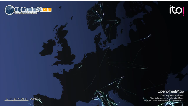
Flights disruption, morning of 18 April 2010 © ITO via Wikimedia
The only alternative at that time was to close airspace completely. We learned a lot from that crisis as a community of volcanologists, as a community of atmospheric modellers, as a community charged with monitoring where the ash cloud went and also the aviation authorities and aircraft-engine manufacturers. During that crisis, the zero-tolerance policy to ash was changed to thinking of it more as a threshold of concentration that was acceptable. Learning was significant there. Many times ash clouds do rise with aircraft routes going through them, but normally it is a lot easier for aircraft to go around the cloud. It being stretched over such a dense area of population made it particularly challenging.
Volcanoes warning us
Volcanoes often do give us some warning that they are going to erupt, but there are many challenges related to it. We look for warnings such as changes in very small earthquakes or seismic signals. They are much smaller than the big earthquakes that make the news for destroying cities, but nonetheless, we can use the signals from around volcanoes to understand more about how the magma is moving inside the plumbing system. We can look at how deep the earthquakes are, for example, to see where the magma is.
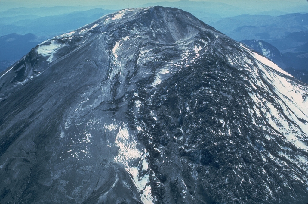 N-flank "bulge" of Mount St. Helens, 1980 © William Melson, Smithsonian Institution
They also give us signatures in terms of when gas is moving and in a way throbbing through the mountain, probably one of our really key things. Then we build that together with other strands of evidence. We look at the way the volcano's shape, or the shape of the Earth, is changing — because if magma is moving, and it's building up pressure in different parts of the system, we might see an impression of swelling up like a blister, as we did in the Mount St. Helens case in 1980. We can look at the way the Earth is shaking; we can look at the way its shape is changing; we look at changes in the gases that are coming out, and we can look at changes in the heat — the thermal-signature signals coming out as well. We can build all these different things together with an understanding of how the volcanoes behaved in the past, and taking these strands together gives us the best possible chance of predicting what it is going to do next.
Obstacles to accurate predictions
It is still not perfect, but all these strands of evidence together can really help us. What is very challenging is when we don't have good monitoring. Many different parts of the world do not have the same resources, or the volcanoes are very remote, so we don't have very good monitoring networks on these volcanoes. In more modern times, satellites have started to play a really key role. We cannot do seismicity from space, but we can look at the way that volcanoes are changing from space using radar satellites. This has been incredibly powerful, because it has allowed us to build up more of a global picture of how volcanoes behave, rather than just looking at individual volcanoes one by one. I'm really hopeful that we will continue to do an ever better job at being able to predict whether a volcano is going to erupt or not. It is still a challenge to be able to say it is definitely going to erupt — or we think there is a high probability that it is going to erupt — in the next six months. However, that is not incredibly helpful if you are a hazard manager charged with monitoring the situation, because you cannot evacuate a city for six months. What you really need to know is whether it is going to erupt in the next two days, and that is much more challenging.
Living near volcanoes
People live with volcanoes in many different ways, and sometimes it is by necessity. They are living in a place where the population is very constrained, they need to find land, and the cheapest land is near the volcano. It is not always necessarily a matter of choice, but there are also times where people choose to live near volcanoes for very good reasons.
 Cesaro, Sicily, with Mt. Etna at dawn © Sean Pavone via Shutterstock
If you go somewhere like Sicily, Mount Etna changes the hydrology and the water cycle there. More rain falls around Etna than in many of the other parts of Sicily. The scattering of ash that occurs relatively regularly on Etna is a great source of nutrients to the soil as it breaks down and releases different elements within the ash. Actually, there are advantages in terms of agriculture. There might also be advantages in terms of tourism. Volcanoes are often very beautiful places; there are beautiful mountains, and there are exciting volcanic experiences that you can have associated with them. People often accept that they're going to live near this volcano, and the volcano gives them a lot in terms of the different resources that they need, but they realize it is also going to lash out from time to time. On Etna, there is an acceptance that the volcano will continue to erupt. Fortunately, it normally erupts on its upper flanks, but occasionally the lava flows do threaten local villages. Then they have to be pragmatic. They often have mythology; it is a religious experience as well. Living with the volcano is very much part of their lives.
Santorini’s striking geology
Santorini in Greece is one of the volcanoes I have worked on a lot. It is an absolutely spectacular place. If you get the chance to go there and you have not been, then go. It is incredible. It has amazing cliffs, and they are stunning; to the naked, untrained eye they look striped with a variety of different colors in them.
 Nea Kameni island, Santorini caldera.© Aerial-motion via Shutterstock
Actually, to a volcanologist, that is the volcano's history laid bare. It is absolutely beautiful, and it is a fantastic place to study volcanology, to learn and study the volcano. Santorini is a volcanic system; it is a series of islands, five different islands. Thira is the largest island, shaped like a crescent moon, and then Therasia and Aspronisi make up a fragment ring around the edge. In the middle, there are two new volcanic islands called Paleo and Nea Kameni, the latter of which means ‘new burnt’ in Greek.
Explosive cycles
What Santorini does as a volcanic system is build itself up, so the Kameni islands are currently building up — the last eruption was in 1950 — and they build up in lava flow after lava flow and volcanic domes. It builds up an edifice. At some stage, the edifice gets big enough to stop future eruptions, and a large amount of magma can build up under the system. Then it has these absolutely enormous explosive eruptions, and they devastate the islands and empty out the Earth's shallow crust. Afterward, they leave collapses, called calderas — enormous craters — and that is what created the bay at Santorini. The last of such highly explosive eruptions was what is sometimes called the Minoan eruption, as it coincided with the Minoan civilization in the area of Crete and Santorini, in the late Bronze Age. There were Minoan settlements; there were what are sometimes called the Pompeii of Santorini at Akrotiri, which is being partially excavated now, and it is a Minoan settlement that was buried in the late Bronze Age eruption. What is interesting is we have not found any bodies in this settlement. We have also found very few valuable items. That tells us the inhabitants received warnings, which they heeded. We think there were small explosions that scattered some fine layers of ash over the island before the really big eruption happened. The hypothesis is that the Minoans fled, possibly back to Crete, which was the center of their civilization, and escaped with their belongings and their lives before the really destructive force of the eruption set in.
Santorini’s next eruption
An enormous explosive eruption will happen again in Santorini's future, but all the evidence at the moment points to the fact that it is in one of these building phases, with many small eruptions every few decades. The last one was in 1950, so there will be another eruption of Santorini; we do not quite know when. It shows unrest from time to time, so there will be another.
 Nea Kameni island, Santorini caldera © Pietro Basilico via Shutterstock
The most likely scenario will likely be a dome-building and lava-flow type of eruption on the Kameni islands. It will have some small explosive activity, but it will not devastate the islands. It will be unpleasant, potentially, in terms of the ash and the gas that the islands may experience. It will also be quite spectacular and possibly interesting for tourists to look at as well, and it will last potentially for a few years. It is again an example of how, by looking at a volcano's past, we can try to do the best job predicting its future.
The Big Five extinctions
If we look in the geological record, what we see is species diversity. The number of species that we see evidence for in the geological record is not constant through geological time. We go through periods of very large-scale species diversity, and then we go through these big contractions where lots and lots of species die out all at once. We call these mass extinction events. There are many small contractions in the number of species in the geological record, but we often refer to the Big Five mass extinction events.
 Geologic timeline © Wikimedia
The most recent of those, and probably the most famous, is the end-Cretaceous mass extinction event, which is where we lost the non-avian dinosaurs. There are other, even bigger ones, however, in the geological past. There is the end-Triassic mass extinction, which predates the end-Cretaceous, and then the largest one of all is the end-Permian mass extinction; it is the biggest mass extinction event in Earth's history. There are others in the Devonian and the Ordovician if we go further back in geological time. If we take the three most recent examples — the end-Cretaceous with the dinosaurs, then the Triassic and the end-Permian — and possibly an older one as well, the geological record gets more and more difficult and incomplete as we go further back in time.
Large igneous provinces and extinctions
Each of the most recent three coincide with something called a large igneous province. A large igneous province is an enormous outpouring of largely basaltic lavas onto the surface of the planet, and it happens over about a million years. It is triggered by an enormous hot plume of material coming up, possibly from as deep as the Earth's core-mantle boundary, and gradually convecting its way up very slowly, until it gets to the surface. It then causes a large-scale melting of the mantle, which drives this million years of heightened volcanic activity. We have evidence for large igneous provinces — from the Deccan Traps, the Central Atlantic Magmatic Province and the Siberian Traps — coinciding with all three of those mass extinction events. With the Cretaceous, there is the Chicxulub impactor hitting the planet near what is now Mexico, so that is happening as well. With the other two, we do not have any evidence of a meteor or an impactor hitting. We think that the large igneous provinces play a really key role in triggering the mass environmental change that contributes to the mass extinction event.
At some stage, there will be a large igneous province again, but we have far more immediate concerns on our hands at the moment. The greatest contender for the sixth mass extinction event is really the global change triggered by mankind's activities.
Lessons from volcanoes
The messages that volcanoes send us are manifold. One of them is really about the immense power that our planet has. Within that is a message of our own insignificance.
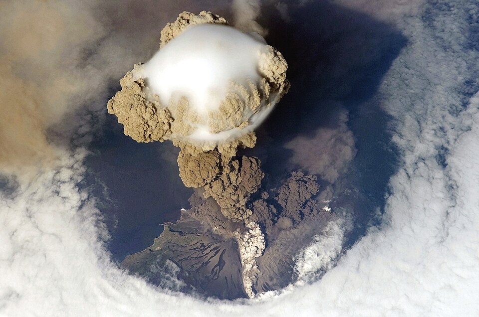 Sarychev Peak Volcano erupts June 12, 2009, on Matua Island. Astronaut photo from ISS © NASA via Wikimedia
Volcanoes are part of the global balances we have in terms of inputs and outputs to things like the atmosphere. In a positive sense, regardless of what we are doing to the planet, the planet will eventually sort itself out. We probably will not be a part of that if we don't watch ourselves, but the planet itself will sort itself out, and a future civilization will potentially take our place. In looking to volcanoes and their power, recognizing our own power as well, we recognize that with that power comes a great sense of responsibility.
Editor’s note: This article has been faithfully transcribed from the original interview filmed with the author, and carefully edited and proofread. Edit date: 2025
Discover more about
life with volcanoes
Mather, T. A. (2024). Adventures in Volcanoland: What Volcanoes Tell Us About the World and Ourselves.. Abacus.
Pyle, D. M., & Mather, T. A. (2009). Halogens in igneous processes and their fluxes to the atmosphere and oceans from volcanic activity: A review. . Chemical Geology, 263, 110–121.
Mather, T. A. (2015). Volcanoes and the environment: Lessons for understanding Earth’s past and future from studies of present-day volcanic emissions. . Journal of Volcanology and Geothermal Research, 304,Journal of Volcanology and Geothermal Research, 304, 160–179. 160–179.
Mather, T. A., & Schmidt, A. (2021). Environmental effects of volcanic volatile fluxes from subaerial large igneous provinces.. In R. E. Ernst, A. J. Dickson, & A. Bekker (Eds.), Large igneous provinces: A driver of global environmental and biotic change (pp. 103–116). American Geophysical Union.
Continue exploring


Explore this knowledge network
Continue exploring...
0:00 / 0:00